

High-Precision GNSS & RTK Solutions
for Surveying and Construction

LRTK is a high-precision GNSS positioning platform capable of capturing absolute coordinates with up to half-inch accuracy. Designed to transform surveying, construction, and civil engineering workflows, LRTK combines advanced RTK technology with mobile devices, drones, and LiDAR systems—enabling professionals to easily acquire georeferenced point clouds and reliable spatial data with exceptional efficiency and scalability.
A New Generation of RTK Devices
for Simple and Efficient Surveying
Smartphone-Based Photogrammetry with RTK Positioning
Capture accurate, georeferenced 3D models exactly where and when you need them—without special cameras, complex workflows, or bulky equipment. Simply take photos with your smartphone and let RTK positioning handle the accuracy.


RTK-Positioned LiDAR Scanning Beyond 500 ft
Scan large structures and hard-to-reach areas from up to 500 ft (150 m) away while keeping every point georeferenced with RTK/GNSS positioning—no markers or tedious setup required. Capture clean, survey-ready point clouds for bridges, slopes, facades, and corridors, then move straight into measurement and sharing through cloud workflows.


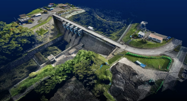
Drone Photogrammetry
Turn drone photos into georeferenced point clouds and mapping deliverables—entirely in the cloud, with no high-end PC or complex setup. Upload your drone image folder to LRTK Cloud to generate point clouds and orthomosaics, then measure distance/area/volume, create contours and as-built heatmaps, and export CAD-ready outputs (DXF) for faster surveying and construction workflows.
Every LRTK Device Comes with a Dedicated Professional App
The dedicated LRTK app works across all LRTK devices, serving as a unified interface for high-precision surveying workflows. It receives positioning data from LRTK and enables scanning and data capture with absolute, georeferenced coordinates, ensuring every measurement is accurately tied to the real world.
When connected to LRTK Phone, the app further enables smartphone-based capabilities such as coordinate capture, coordinate guidance, inspection photo documentation, and precise AR-based layout that aligns correctly with design data. By combining absolute positioning with an intuitive mobile interface, complex surveying tasks become easier, clearer, and more reliable in the field.


Upload to the LRTK Cloud with an Integrated 3D Viewer
All data captured with LRTK can be synchronized to the LRTK Cloud with a single tap, making it easy to access and share results across devices and teams. Switch seamlessly between 2D and 3D views to explore your data from different perspectives, and interact directly with georeferenced point clouds.
Measure coordinates, distances, areas, and volumes with ease, generate heatmaps to compare as-built point clouds with design data, and create contours or orthophotos as needed. With the integrated 3D viewer and cloud-based tools, LRTK turns captured field data into actionable insights—without complicated software or workflows.

